English | Dutch |
|
| Trekking in Ladakh, land of the high passes | |
Leh (India), September 22nd 2007 |
|
Our initial plan was to do the trekking to the K2-basecamp, in the north of Pakistan. This trekking to the K2-basecamp is already high and long on our wish list. However, due to the unrest in Pakistan during the summer of 2007 (following on the evacuation of the Red Mosque), we decided to cancel the trekking to the K2 and leave Pakistan for India. So, we sought for an alternative. We found the alternative in the very northwest of India, in the area called Ladakh. The first idea you might have is that the area Ladakh is less spectacular than the K2 area. Indeed, you are not walking between peaks of more than 8000 metres in Ladakh. But there is something else that makes Ladakh special. The name Ladakh explains it already: “land of the high passes”. Because of its high basic altitude, most trekkings in Ladakh are high altitude trekkings. The trekking that we did for example was for more than 90% above 4500 metres, with some passes exceeding 5400 metres. If you realize that the Mont Blanc in Europe (highest mountain in Western Europe) is only a little bit more than 4800 metres, you will be conscious of the altitude of this area and the peculiarly of hiking is this area. |
|
 |
|
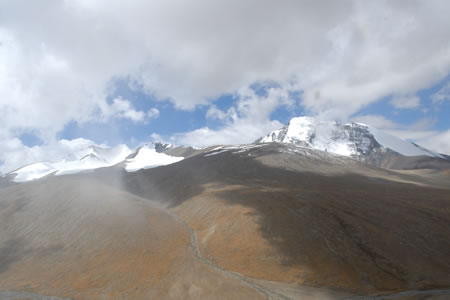
Beautiful view on the 6394 metres high Kang Yissay from Gongmaru La. |
|
Many people are deterred to hike on this high altitude. It is true that you have to be careful to trek in an area like Ladakh. Acute Mountain Sickness (AMS) is a serious sickness that can be fatal. For this reason, a good acclimatisation is essential. We stayed two weeks in Leh on an altitude of more than 3500 metres, as preparation for the trekking. Besides that, you have to be sure that you do not ascend to fast to high altitudes during the trekking. Some theories say that you need three acclimatisation days for every 1000 metres of ascend, but in reality that’s often very difficult. During our trek for example, we hiked from 3687 metres to 4757 metres on day one, and crossed a pass of 5355 metres on day 2. But always keep in mind that if you develop symptoms of AMS, you do not climb further and preferably descend till the symptoms are gone. Some trekkers decide to take medicines against AMS. However, their use is controversial. They can reduce the symptoms, but that may also mask warning signs. So, the use of these medicines can be fatal. The real altitude of the passes and camping places in Ladakh seems to be unclear. The trekking maps show different altitudes for the same passes, and also the guides do not have a definite answer. For that reason, we believed in the accuracy of our GPS during the trek for measuring the altitudes. Our GPS showed us that during our trek, Yalung La (5445 metres) was the highest pass we crossed, and “Gyamsumdo” (5163 metres) was the highest camping place we slept. A very light headache once in a while was the only symptom we had during the trekking. The trekking we did by the way, started in the small village of Shang (near Hemis, one and a half our drive south of Leh) and ended twelve days later at the lake “Tso Moriri”. It consists of two different parts. The landscape of the first four days was characterized by rough mountains and small valleys. The landscape changed after the village of Rumtse. The rough mountains are replaced by rolling mountains, and the valleys become more wide and extensive. The vegetation in both parts is minimal. The maximum height of the bushes (if any) is knee height and you will only find grass near the small rivers and brooks. There where you’ll find grass, you probably also find the herdsmen with their cattle (sheep, goats, yaks) to feed the animals. The colours of the mountains change by location and time of the day. It is really a great place to hike! | |
 |
|
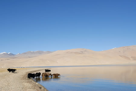
Yaks are taking a bath in the lake "Tso Moriri". |
|
| Most trekkings in Ladakh can be done by everybody who is fit, and more importantly, who has the attitude to succeed the trekking. It is also important to realize in what season you want to trek. Because of the huge amounts of tourists during the high season (half of June till the end of August), you are one of the many, many trekkers. We even heard that it is very difficult to find a camping place for your tent on one of the dedicated camping areas in this season. Many trekking agencies send an extra guide with the trekkers in the high season, to “run” to the next camping place to secure a camping site for the trekkers. Be prepared to walk in string on the hiking trails during the high season. We did our trekking from September 9th till September 20th, and we only saw two other groups during the whole trek. And of the eleven nights we spend on the camping sites, we were alone nine times. That was for us the main reason to do the trekking outside the main season.
Of course, there is also another side on the medal. It can be (very) cold in the mountains at the beginning and end of the season. During our trekking, the temperature at night dropped well below freezing (-5 till -10 degrees Celsius). It is also cold during the day when the sun is not appearing due to clouds, mountains or because of sunset. Especially when you finished hiking for that day, your sleeping bag will be the only comfortable place to be when the sun is gone. Besides that, we had some days with snow, making the trails less visible. We experienced the snow as an extra, because it gives an extra dimension to the trekking. If you do not like the cold, you better go in July or August. On the other hand, if you do not mind the cold, avoid the busy season. The peace that you get outside the busy season is one of the highlights of the trekking. Another advice we have is the following. Be sure that you also take a toilet tent on your trekking. You can use this tent for your “missions”, but can also use it to find the necessary privacy to wash yourself once in the few days. If you do not have a toilet tent, like we did, you have to find a “private” spot somewhere in the area of the campsite. And if you know that the highest vegetation is only knee height, finding this place is probably the most difficult task of the whole trekking, especially in the busy season when you share the campsite with plenty other trekkers. See also weblog: “tasteful trekking” | |