English | Dutch |
|
| Mt. Damavand: Climbing a heavy smoker | |
Tehran (Iran), July 14th 2007 |
|
Mt. Damavand isn’t just a mountain; this 5671 meter high mountain fills the Iranians with pride. He isn’t only 800 metres higher than the Mont Blanc, but it is also a fervent emitter of sulphur. We do not only want to see Mt. Damavand on the local paper money or on the label of the Damavand mineral water, we also want to climb it. As rather inexperienced hikers we have made an appointment with Hamid. Because Mt. Damavand is known for its unpredictable weather and its heavy sulphur fumes we want to have an experienced guide like Hamid with us. Moreover, the height is a real factor to take into account. Within a few days you climb till 5671 metres height, which can cause serious altitude sickness. Unfortunately, this already caused the lives of some climbers. On Wednesday 11th of July we start on 2950 metres (first base camp) to conquer the first 1200 vertical metres. A rather straightforward path winds its way up to the Southern slope of Mt. Damavand. In the first few kilometres we pass several big flocks of sheep. While the mountaintop is covered with snow, at this moment we are still surrounded with thistles and poppies. The temperature is very nice and after a few days of smoggy Tehran we appreciate the fresh air even more. |
|
 |
|
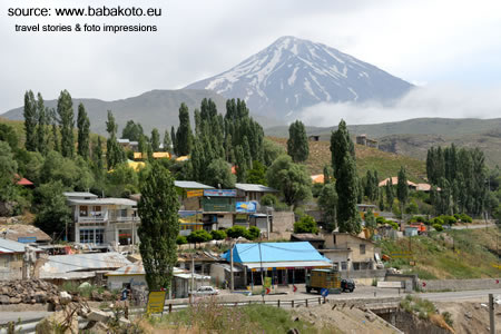
A beautiful view on Mt. Damavand from the village of Pooloor. |
|
We walk at a nice steady pace and after a few hours the poppies have disappeared out of the landscape. The vegetation made way for rough rock formations while the temperature dropped considerable. With a fierce breeze it feels rather cool. After 3.5 hours we arrive at the second base camp on 4150 metres height. The camp has a shelter, in which some climbers can sleep, but we have hired a tent and the view is marvellous. Fortunately, we both haven’t big problems with the height. We only have a slight headache. However, in the camp we see people suffering from much more height related problems. Therefore, it is wise that people plan an extra acclimatisation day before they try to reach the top at 5671 metres. That extra acclimatisation day was also on our schedule, but because we feel rather fit we decide with Hamid to do our “top attempt” next morning. After all, Fridays are normally busier than Thursdays, because the weekend starts here on Thursday afternoon. Local climbers (accounting for 95% of the total amount of climbers) use the Thursday afternoon to get to the second base camp and climb to the top on Friday. Thursday morning we start at 7.00 on our way to the top. Travel books mention that the climb should take +/- 7 hours and the descent another 4 hours, so we are mentally prepared for a long day. The first 3 hours are relatively easy. The landscape is getting rougher while the weather gets wintry. After 5100 metre height, the path is getting less straightforward and steeper. Moreover, the higher you get the more you will start to smell and see plumes of sulphur. In these conditions you really see the difference between a well trained climber as Hamid and us. When the steeper paths also get covered with loose gravel we really have difficulties to continue at a good pace. Because of the cold it’s not good for your muscles to take long rests. However, because of the height you really need a breaker from time to time to take some deep breaths before you can carry on. Moreover, the height causes headache and dizziness. The whole morning we are just behind a group hikers from Kurdistan, but the last 500 metres we have to let them go. In these last 500 metres we meet the man with the hammer and we notice that we probably started too quickly. Due to the height and exhaustion we need to rest every few steps we take. Finally we arrive at the top at 12.00. Climbing this +/- 1500 vertical metres in 5 hours isn’t bad at all, but when knowing how tired we are, you also understand that is was probably wiser to take 6 hours for the ascent. Now we know how it feels when your head wants to move forward and your feet disagree. | |
 |
|
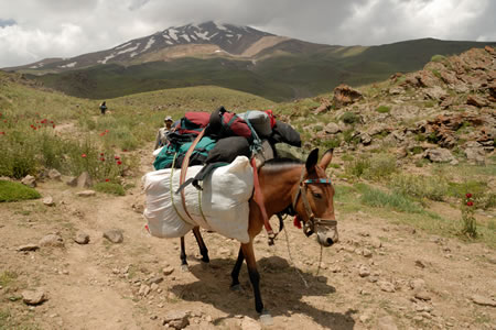
The mule is the 'truck' of Mt. Damavand. |
|
| When reaching the top, we are most warmly welcomed by the Kurdish hikers. Everyone wants to take his picture with us, and numerous group photos are taken in only a few minutes. Because it started snowing and the wind started turning, the chances on heavy sulphur damps and unforeseeable weather grow. Therefore, we only stay 5 minutes at the top before the descent begins.
The descent follows another path consisting of more gravel and loose rocks. The more experienced (and less exhausted) hikers literally run down on this path, but we decide to spare our knackered legs by walking slowly back to the base camp. The closer we come to the base camp, the more people we meet. These people want to climb the top tomorrow and already want to practice a bit. Honoured with many congratulations and compliments, we arrive tired but content at the base camp. All in all, the descent took us 3.15 hours and luckily Hamid walked ahead to prepare nice tea from the herbs that he picked the day before. It tastes great after al the hard work. More and more Iranians arrive at the base camp for their weekend trip and the atmosphere is great. Mt. Damavand looks down on us again while he blows out his sulfur plumes. It is a great feeling to have climbed this heavy smoker. After a good night sleep we are feeling fit again. In 2 hours we walk back to the inhabited world at 2950 metres. Slowly, we see the poppies again and the sheep welcome us. Although we have seldom been as tired as when climbing Mt. Damavand, we wouldn’t have want to miss it for a thing. See also the photo impression of Mt. Damavand. | |